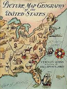
Picture Map Geography of the United States
Author:
Vernon Quinn
Illustrator:
Paul Spener Johst
Publication:
1931 by Frederick A. Stokes Company
Genre:
Geography, Non-fiction
Series:
Picture Map Geography ![]() Members Only
Members Only
Pages:
200
Current state:
Basic information has been added for this book.
It is under consideration and will be updated when it is evaluated further.
Book Guide
Search for this book used on:
Here's the new way, the delightful way, to learn geography.
The picture maps—there is one for each State, Hawaii and Alaska—show by pictures all those things that are usually so confusing to the young mind—leading products, capitals, chief cities, rivers, bays, boundaries. The child will learn these visually while he is looking at the pictures.
The text, in keeping with the maps, is told in a lively way to hold the interest of young readers. Bits of Indian lore give individuality to each State, and at the same time they keep the small reader's attention.
It is not a text-book. It is a picture-book for the child to enjoy at home. (Of course, schools will like it, too. And libraries will welcome it as something new and worthwhile for their youngsters.)
With 50 full-page picture maps, and endpaper and jacket in full color, it makes an attractive gift-book for children from eight to thirteen.
From the dust jacket of the 1941 Picture Map Geography of South America

Vernon Quinn
1881 - 1962American
Elizabeth Vernon Quinn has an enviable reputation for her fine and trustworthy books in the fields of geography, history, and nature study. She has ... See more
Paul Spener Johst
1881 - 1942Paul Spener Johst was an American artist and illustrator. Johst illustrated many books, was responsible for the creation of a series of maps of the ... See more
To view reprints of this book please sign in.
Find This Book
Search for this book used on: